Other
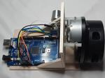
“Let’s pick magic chimes out of the air with a LIDAR scanner and an Arduino. There are many exciting things that you can do with laser. One of these is playing harp! In this project, a LIDAR scanner (LIDAR …


Lidar is a surveying method that measures distance to a target by illuminating the target with laser light and measuring the reflected light with a sensor. Differences in laser return times and wavelengths can then be used to make digital 3-D representations of the target. The name lidar, now used as an acronym of light detection and ranging (sometimes, light imaging, detection, and ranging), was originally a portmanteau of light and radar. Lidar sometimes is called 3D laser scanning, a special combination of a 3D scanning and laser scanning. It has terrestrial, airborne, and mobile applications. Lidar is commonly used to make high-resolution maps, with applications in geodesy, geomatics, archaeology, geography, geology, geomorphology, seismology, forestry, atmospheric physics, laser guidance, airborne laser swath mapping (ALSM), and laser altimetry. The technology is also used in control and navigation for some autonomous cars.
“Let’s pick magic chimes out of the air with a LIDAR scanner and an Arduino. There are many exciting things that you can do with laser. One of these is playing harp! In this project, a LIDAR scanner (LIDAR …