
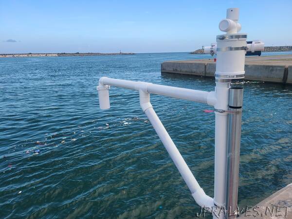
“Inside a protective shell made of 3D-printed acrylic polymer, a cone-shaped ultrasonic sensor measures the time it takes for intermittent sound waves to bounce back off the rapidly rising water beneath, then sends the data to scientists and community managers who monitor the streamflow from afar. This seemingly small instrument, about the size of a trumpet or trombone, is now part of a much-needed observation system that will help provide early warning of high-impact weather events, like flash flooding, in isolated areas. These new, inexpensive and easy-to-deploy instruments enable people in remote regions of the world to better measure streamflow, storm surges, and snowfall in ways that will better protect society and even save lives.
A project at the University Corporation for Atmospheric Research (UCAR), called 3D-PAWS (3D-Printed Automatic Weather Station), is adding a new set of remote-sensing capabilities that will measure streamflow, storm surges, and snowfall depth to its suite of successful 3D-printed weather stations. This initiative will bring low-cost remote sensing instruments to the world’s “unseen” areas.
The initial 3D-PAWS initiative began five years ago as a mission to make weather data collecting more accessible. Designing instruments out of 3D-printed parts means underserved communities can collect their own data for weather forecasting for a fraction of the cost without sacrificing accuracy.
“Our goal is to enable our end users to make and sustain their own networks rather than getting commercial sensors, which could cost several thousand dollars,” said Paul Kucera, a project leader for 3D-PAWS. The 3D-printing capability of the instruments allows communities to print and create their own instruments, rather than relying on expensive manufacturers. Now 3D-printed weather stations are currently filling data gaps in regions in Barbados, Kenya, Uganda, and Zambia.
After the initial success of the weather stations – which collect rainfall, humidity, temperature, and pressure data – the 3D-PAWS project is working with community partners to produce a new set of remote-sensing capabilities. One type of ultrasonic sensor can be used in three distinct ways: detecting streamflow changes, sudden storm surge rising on the shore, and snowfall in remote mountain areas.
“We are getting much closer to creating a useful warning system,” said Martin Steinson, the mechanical engineer and instrument designer for 3D-PAWS. “We will be able to combine weather stations and stream gauges to provide information that can impact people’s daily lives.”
3D-PAWS was launched by UCAR and the U.S. National Weather Service International Activities Office, with support from USAID. The initial weather stations were developed with support from scientists from the National Center for Atmospheric Research, which is managed by UCAR on behalf of the National Science Foundation.
“It is extremely exciting to build capacity in other areas,” said Kucera, who has a background in international capacity development and works to train communities in environmental sciences and enable independent data collection. “It is what I love to do: take our knowledge and expertise and help people in need.”
STREAM, SURGE, AND SNOW
The new 3D-PAWS sensor was initially developed to measure the flow of water to help predict potential flooding and snowmelt runoff. The project partnered with streamflow sensing expert Anne Heggli to help produce and test a low-cost stream gauge that would be easy to handle in the field. Heggli’s expertise helped the team settle on an ultrasonic sensor – a widely recognized measurement tool that is still affordable and easy to set up.
“Regions that are data poor don’t need something super accurate like radar, which is also expensive. They can benefit just as much from a sensor that is reliable and cost effective, and that is what we are doing,” said Heggli.
Ultrasonic sensors use sound waves to send and receive pulses, measuring the time it takes between sending the ultrasonic wave, then receiving it when it has bounced off the surface of the stream, to measure the changing height of the water.
Heggli put the 3D-printed instruments through their paces of field deployment, bringing feedback and suggestions back to the 3D-PAWS team to help them improve the product. “Users should be in charge of their own sensors, deploying them and fixing them themselves,” she said. “Providing users autonomy over their own data and their own networks is important.”
Once streamflow monitoring proved successful in the field, Kucera and his colleagues saw potential for applying the same sensor to monitor storm surge, an often-dangerous rise of sea level caused by tropical cyclones or other powerful storms. Partners at the National Office of Meteorology (ONAMET) in the Dominican Republic are now testing the sensors’ ability to monitor and warn coastal communities of sudden and potentially deadly flooding from the sea.
“It is extremely important to have real-time information of the changing tides associated with the arrival of a tropical cyclone,” said meteorologist and ONAMET deputy director Andres Miguel Campusano Lasose.
Sensors currently in place at the mouth of the two main rivers that lead to the capital city of Santo Domingo, and their potential to provide early warnings could help protect businesses and homes. The installed sensors initially had some challenges collecting accurate data, said Campusano, but ever since local technicians made some adjustments the gauges are now working as they should.
The ONAMET partners now plan to install two more 3D-PAWS sensors on the northern side of the country. The instruments “help strengthen our early warning systems, which translates into early forecasts to be able to safeguard lives and property, which are in high-risk areas for storm surges in a country that is highly threatened every year by tropical cyclones,” he said.
The third application of the new 3D-PAWS sensor is measuring snowfall, which is also currently in the testing phase at the University of California, Berkeley’s Central Sierra Snow Laboratory (CSSL). Located at Donner Pass in the Sierra Nevada mountain range, two snow sensors are being tested against the capabilities of tried-and-true snowfall measurement systems. “What is needed is a durable, low-maintenance sensor that can transmit data, so someone does not need to travel to collect it,” said Andrew Schwartz, the station manager and lead scientist at CSSL. “The benefit of the 3D-PAWS sensors is that they are self contained and don’t need all the expensive equipment taking up a lot of space.”
Schwartz already has some preliminary feedback on the snowfall sensors from the first field deployment that measured a record-breaking snowfall of 214 inches (more than 17 feet), which accumulated across two and a half weeks in December of 2021. “The 3D-PAWS sensors have done exceedingly well, even with the heavy snow,” he said.
According to his measurements, there was about an inch difference in the snowpack height reading between the 3D-PAWS sensors and the established sonic snow-depth sensor at the laboratory. Though still early in the testing phase, he noted that the data difference is likely due to the distance between the two types of sensors, which are located approximately 50 feet apart. “That is more than enough distance for the snowpack to change by an inch,” he said. “It is an exciting start to the project.”
Like the stream and storm-surge capabilities, there is a global need for an inexpensive and easily deployable snowfall sensor. Remote mountain regions rely on snowpack to replenish water resources, but there is also a high risk of flooding. Observations in regions like the Himalayan mountain range, which spans multiple countries across Asia, could use these sensors to monitor snowfall and help local communities forecast water resources and reduce flood risk.
HEALTHY AIR, PRODUCTIVE CROPLAND
Even as capabilities are being put to the test in the mountains, streams, and coastlines, Kucera and his colleagues already have their eyes on the next 3D-printed instrument challenges: soil and air quality.
Though these instruments are just in the preliminary stages of development, the 3D-PAWS scientists and engineers are hoping to create a sensor to monitor air quality in urban environments. The World Health Organization estimates that nearly 4 million people die prematurely due to household air pollution, typically from inefficient cooking and heating within the home. Low-cost air quality monitors that can sense ozone or dangerous smoke emissions levels could be deployed within neighborhoods or homes and help prevent illness associated with severe pollution.
“Air quality measurements are a challenge. There is a fine balance between instrument cost and sensitivity where it can capture things like ozone,” said Kucera. The new air quality sensor is currently in the lab testing stage, but field deployments for testing are on the horizon.
Simultaneously, Kucera and his colleagues are working on a sensor that can monitor soil moisture and temperature levels and help farmers better anticipate when they need to plant crops or irrigate. This new instrument was a suggestion from some of the current partners employing the 3D-PAWS weather stations. “Our partners and contributors are the ones who pointed out they could use soil moisture measurements to save crops and improve yield,” said Kucera. “It is feedback from the end user that informs the science.”
Overall, it is this partnership between the 3D-PAWS project managers and the instrument users that is steadily growing the monitoring and data collection capacity in underrepresented areas of the globe.
“In 3D-PAWS we have partners who have become fully independent, which is our goal,” said Kucera. “We want them to take off and run with it. I hope we can continue to spread the pawprint around the globe and improve community forecasting.””