
“Harmful algae can endanger public health and coastal ecosystems and economies. Advances in satellite imaging are providing new ways to look at our living ocean.
By the time they were over, a series of massive algal blooms along the west coast of Florida in 2020 would be linked to some 2,000 tons of dead marine life around Tampa Bay. The human costs were stark, too, including a double-digit increase in asthma cases in Sarasota and Pinellas counties, and estimated losses of around $1 billion across economic sectors from tourism to fisheries.
Earth-orbiting satellites have been used for decades to detect algal blooms from space, enabling more frequent observations over broader areas than is possible by directly sampling the water. The most common observing technique relies on the visible spectrum to measure ocean color. However, this approach has been mostly restricted to clear sky conditions.
A recent study, led by scientists at NASA’s Jet Propulsion Laboratory in Southern California, has shown how one space-based instrument called TROPOMI, or TROPOspheric Monitoring Instrument, was able to peer through thin clouds to uncover powerful clues about Karenia brevis (or K. brevis), the microscopic algae responsible for the 2020 blooms. TROPOMI’s enhanced ability to “see” and measure fine wavelengths of light could potentially help federal agencies and local communities better forecast and manage harmful outbreaks. (TROPOMI flies aboard the European Sentinel 5P spacecraft, which was launched in 2017.)
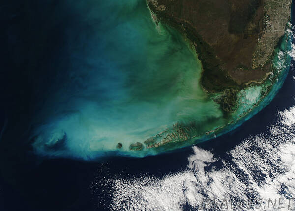
The scientists examined the West Florida Shelf, a stretch of continental crust arcing from the Panhandle to the Keys. From its origins in other parts of the Gulf of Mexico, K. brevis is carried toward the coastline on strong winds and ocean currents. Recent research has shown that western Florida, like many coastal communities, may be increasingly vulnerable to outbreaks because these algae flourish in nutrient-rich, warm conditions fueled by runoff, fertilizer, and climate change.
Florida, like many coastal communities, may be increasingly vulnerable to outbreaks because these algae flourish in nutrient-rich, warm conditions fueled by runoff, fertilizer, and climate change.
Get the Latest JPL News
SUBSCRIBE TO THE NEWSLETTER
Systems for monitoring and forecasting harmful algal blooms are available in many states and coastal regions, including the Gulf of Mexico and Great Lakes. The National Oceanic and Atmospheric Administration (NOAA) works with academic, state, tribal, and local partners to develop and issue harmful algal bloom forecasts – similar to weather forecasts – during the seasons when blooms occur.
K. brevis events are especially concerning because the algae produce a potent neurotoxin that in high concentrations can cause massive fish kills and poison marine life such as turtles, manatees, and birds. The toxin can also be inhaled, causing respiratory illness in humans, and it can accumulate in shellfish, resulting in gastrointestinal illness in people who consume them.
As the algae feed and grow via photosynthesis, K. brevis emits a faint red glow called solar-induced fluorescence (red SIF) that can be detected by some satellite instruments including TROPOMI, which was actually designed to measure air pollution.
Sifting through TROPOMI data acquired along the coast of western Florida between 2018 and 2020, the team found that the instrument gathered about twice as much fluorescence information emitted by the algae as observed by previous methods that rely on ocean color. TROPOMI’s advanced imaging capabilities – including four spectrometers measuring light ranging from the ultraviolet to shortwave infrared – enable it to penetrate thin cloud cover and obtain measurements of the ocean surface more frequently.
Space-Based Advantage
The scientists said their findings demonstrate the value of using TROPOMI by itself or in concert with other Earth-observing tools such as NASA’s longtime MODIS (Moderate Resolution Imaging Spectroradiometer) instrument, aboard the Aqua and Terra satellites. MODIS measures ocean color and is currently being used by environmental managers in Florida and other places to detect algae on clear days.
Another ocean color instrument – scheduled to launch early in 2024 – will look at the world’s marine ecosystems like never before. NASA’s PACE, or Plankton, Aerosol, Cloud, ocean Ecosystem mission, will study phytoplankton and other ocean biology, atmospheric aerosols, and clouds in many more wavelengths than previous sensors. These observations will help forecast the appearance of harmful algae, as well as the boom-bust cycle of fisheries and other factors that affect commercial and recreational industries.
“For nearly 20 years, ocean color sensors have been foundational for satellite monitoring of harmful algal blooms,” said lead author Kelly Luis, a NASA postdoctoral program fellow at JPL. “This application of TROPOMI red SIF demonstrates how the combination of satellite technologies can bolster early warning systems beyond clear sky conditions.”
Early warning via satellite has been shown to have real-world benefits. A recent NASA-funded case study found that early detection of cyanobacteria in Utah Lake led to significant savings on health care, lost work hours, and other economic losses. A few days of advance warning can translate to faster action on the ground, including public alerts and even beach closures.”